
Road Trip | Lake Michigan Circle Tour

Lake Michigan
Circle Tour
3,200 Miles of Coastlines to Explore
The Great Lakes. Upper Midwest. North Coast.
Five interconnected bodies of water containing 21% of the world’s freshwater, making this system of lakes the largest mass of freshwater in the world. In fact, the Great Lakes Region contains 82% of the total freshwater in the United States. Needless to say, many activities in this region revolve around this vast area of water.

Cana Island Lighthouse | Door County, Wisconsin
We begin with the largest, Lake Michigan. The lake in our backyard.
3,200 miles of salt-free shoreline belong to this great lake. The Lake Michigan Circle Tour is roughly an 1,100 mile driving tour that circumnavigates Lake Michigan, the largest lake in the world entirely within one country. This road trip is a journey through Wisconsin, Illinois, Indiana and Michigan full of sand dunes, lighthouses, large cities, historic towns and water everywhere you look.
Traveling along this route has a few options. The trip is broken up into the Northern Route and the Southern Route, or you can traverse the entire lake in one trip which is what we decided to do. Headed south of the border and started our Midwest adventure in Chicago.
Chicago
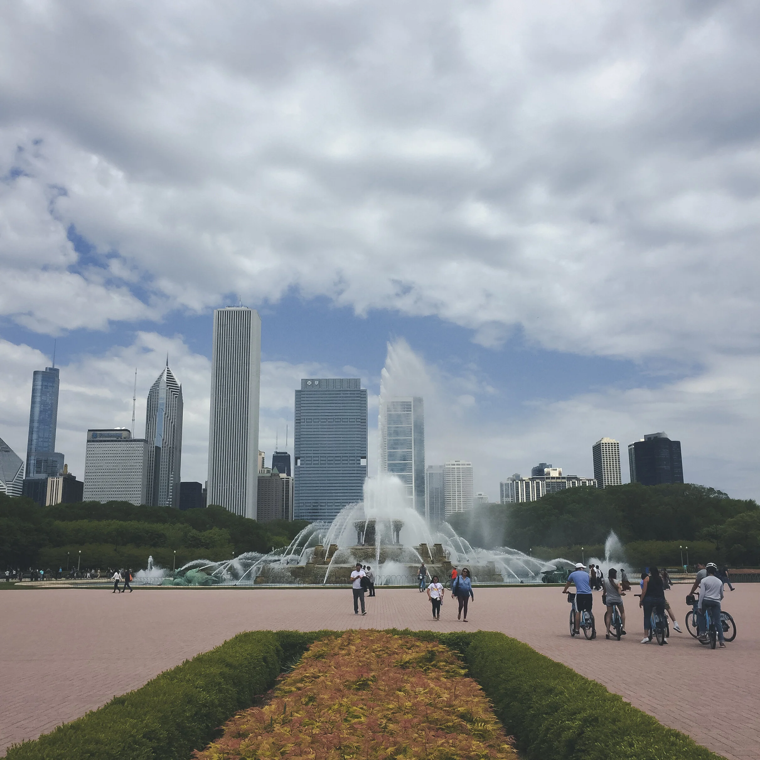
Buckingham Fountain is considered by many to be the “front door” to Chicago. One of the largest fountains in the world sits in Grant Park along the lakefront with the beautiful Chicago skyline in the background. This memorial fountain named after Clarence Buckingham, was beautifully constructed in 1927 and modeled after the Latona Fountain at Versailles. The design of the fountain represents the midwest; the fountain itself is Lake Michigan and each set of seahorses represent the four states surrounding Lake Michigan being Wisconsin, Illinois, Indiana and Michigan. The perfect start to our journey around the lake.
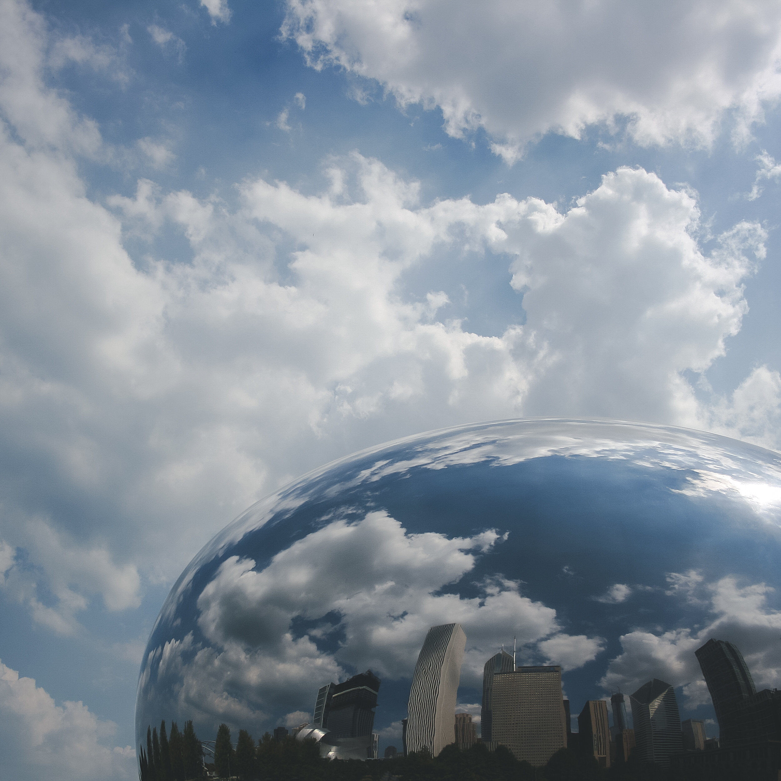
Grant Park is a large urban park with 319 acres and is considered to be the “front yard” of Chicago. This park contains Buckungham Fountain, The Art Institute of Chicago, Millennium Park, The Lurie Botanical Garden, Cloud Gate, the Chicago Lakefront Trail, a dog park, a skating plaza and so much more. A quick water taxi or short bike ride will get you to Navy Pier in minutes.
The start of Route 66 begins in front of The Art Institute of Chicago, just across the street on Adams. Driving this route out of Chicago, you follow Route 66 for its first few miles. The Lake Michigan Circle Tour quickly curves around the bottom of Lake Michigan after crossing into Indiana.


Indiana Dunes National Park
Highway 12, or the Dunes Highway, takes you across the northern edge of Indiana along the southernmost edge of Lake Michigan. What started as Marquette Park in 1919, grew to include Indiana Dunes State Park in 1925 protecting the Dunes Nature Preserve. This area became even more protected in 1966 when congress authorized the Indiana Dunes National Lakeshore, and again in 2019 when it was redesigned as our 61st National Park in the NPS system.
Hiking on trails and dunes, swimming, boating, biking, camping can all be found at Indiana Dunes. Driving through the park you are treated to a display of five Century of Progress Homes now taking residence in Beverly Shores after being moved following the 1933 World’s Fair in Chicago. There are many private beaches in this area so look for signs and watch where you park.
At the eastern end of the park you is Mount Baldy, the largest dune on the southern shores. Just outside of the park, you arrive in Michigan City shortly before crossing the border into Michigan.


Southern Michigan
Between Midwest surfing towns New Buffalo and St. Joseph, lies Warren Dunes State Park. Though one of the smaller dunes parks around the lake, it still has sand dunes to explore, a swimming beach, hiking trails and campgrounds. St. Joseph has the Third Coast Surf Shop, where you can rent surfing gear and even have a Midwest surfing lesson from area pros. Next door in Benton Harbor you can find The Mason Jar Cafe, a perfect spot for breakfast to start your day or brunch after a morning in a wet suit on the lake.
Everywhere you look it seems as if you can find a winery (visit: Fox Barn Winery), or a local fruit stand in this corner of Michigan. The area from St. Joseph extending north to Traverse City is considered to be the “Fruit Belt” of Michigan with apples, blueberries and cherries galore. Leave room in your van for fresh fruit and some bakery items for the road.


Silver Lake Sand Dunes
Silver Lake State Park is a mid-size dunes park consisting of 2,000 acres of dunes, and some you can explore with an OTR vehicle. If your vehicle is not equipped for this, there are rentals in the area as well as guided tours. On the south end of the park is Little Sable Point Lighthouse and extending 22 miles around the area is the fully paved Hart-Montague rail trail for biking or skating through the quiet area farmland. Silver Lake is the perfect place for kayaking, stand-up paddle boarding or sailing and the campground even has a few spots where you can launch right from your campsite. Bring your own water fun or rent from an area vendor that has numerous options for water activities or sand boards for dunes riding.


North Country Trail | Huron-Manistee National Forest
The North Country National Scenic Trail is the 4,600 mile footpath that extends through 8 states from Vermont to North Dakota. Established in 1980, just over 3,000 miles of this trail are currently connected so it is still a work in progress. Even so, it is still the longest National Scenic Trail in the United States, finishing ahead of the Continental Divide Trail in the Rockies by just under 100 feet. A large portion of this trail resides in Michigan, following the western side of the state where is get close to Lake Michigan in a couple places, crossing the Mackinaw Bridge at the Mackinac Straights, then heading north in the UP following along Pictured Rocks National Lakeshore to the Porcupine Mountains over to the border of Wisconsin.


Sleeping Bear Dunes National Lakeshore
Sleeping Bear Dunes covers 35 miles of Lake Michigan eastern coastline created in 1970 to protect that section of the “Third Coast” lakeshore. Several campgrounds can be found in the park including several on South Manitou Island, only accessible by boat. Hiking trails and scenic driving trails can be found throughout this park, plus the iconic 450 foot Dune Climb at the north end of the lakeshore. This 3.5 mile climb can take 3-4 hours so be prepared for this challenge if you so decide. From the top of the dunes or the shores of Lake Michigan, the views all around are stunning and this is a stop not to miss on the route around the lake.


Northern Lower Peninsula
Traverse City is another city known for Lake Michigan surfing. Its a big small city full of food trucks and art galleries and community events. The area is the largest producer of tart cherries and the world, and numerous wineries can be found celebrating their unique fruity creations. Continuing along the North Shore you find Petoskey, a small town know for its name sake, the Petoskey Stone. This stone is actually fossilized coral that can be found in places all along the northern coast. Heading slightly inland is the final stretch of the trip where the Lower Peninsula ends at the Straights of Mackinac.
Mackinaw City | Mackinac Bridge
The Mackinac Bridge is an engineering feat that connects Lake Michigan and Lake Huron at the Straights of Mackinac. Dedicated in 1957, its one of the longest suspension bridges in the world covering over 5 miles. The winds can be very turbulent through the Straights so there are frequent high wind warnings making it a slow 20mph crossing to the Upper Peninsula.


The Upper Peninsula
Just after crossing the Mackinac Bridge, follow the Highway 2 exit. Almost immediately you feel like you’re somewhere else, even more remote. The first stretch of 20 miles has numerous small campgrounds near the water and a few Pasties shops to grab a traditional Upper Michigan bite. Pasties are basically meat hand pies that can be found all over the UP, and are great grab and go foods for the road. One of the most beautiful rest areas in the world exists in Naubinway, MI. This roadside park is dog friendly and has direct access to Lake Michigan.
Hiawatha National Forest
Highway 2 is the Lake Michigan Scenic Highway and for good reason; much of the cruise closely follows the northern coastline with views of Lake Michigan for miles. Its quiet, full of closed down motels feeling like the UP is going back to nature. Nature is more predominant than people up there. 53% of the state of Michigan is covered in forest land make it a destination for recreation no matter your activity. Take advantage of the opportunity to explore the 894,000 acres of the Hiawatha National Forest. Forest campgrounds are everywhere as well as numerous places for dispersed camping and be off the grid for a few days. Small lakes and ponds dot the landscape of the forest so kayaks could be a great addition. Mountain bikes can be used on the numerous forest service roads as well as the few mountain biking singletrack trails setup. Hundreds of miles of hiking trails exist in the forest including 20 miles of The North Country Trail.


Kitch-iti-kipi
Just off the route north of Manastique, lies Kitch-iti-kipi, meaning “big large spring” in Ojibwe and is full of Native American legends. Its Michigan’s largest natural freshwater springs with water so clear you’ll be convinced its not real. Located within Palms Book State Park, its a nice stop en route to the forest.


Wisconsin
At Little Bay de Noc, the roads curves south for its final stretch into Wisconsin along Highway 35 and the Escanaba River State Forest. The road gets quiet again with the exception of a few county parks long Lake Michigan for you to stretch your legs until the border where the Menomonee River separates Michigan and Wisconsin. The road continues south into Green Bay, only to head back north into Door County.
Door County
A very popular Upper Midwest vacation destination, the Door Peninsula has almost 300 miles of shoreline and over 90 beaches or boat launches giving it the nickname the “Cape Cod of the Midwest.” The Door sees most traffic from May through October with some businesses running the on same schedule. Activities can be found year round in the area no matter the season you visit with six State Parks, 11 lighthouses, countless wineries and art galleries.
You can reach the tip of Door County by completing an exciting adventure in itself. First you must travel north on Highway 42 until it ends at North Point. Those visiting the area during the fall colors are in for a special treat on this stretch of road. The Washington Island Ferry will take you and your vehicle across the Port des Mortes, or “Death’s Door” into Detroit Harbor. Washington Island is known for their biannual music festival, home to the largest lavender farm in the Midwest, and 3 parks including Schoolhouse Beach with its unique stone beach.
At Jackson Harbor you can take the Washington Island passenger ferry to Rock Island, or you can kayak there if prepared with ocean kayaks. The entire island of Rock Island is a State Park with hiking trails and 40 primitive walk-in campsites. Nothing else is there so be prepared for what you need whether its a day trip to the beach or an overnight adventure.


Eastern Wisconsin
After leaving Door County, its a quiet drive along the western shore of Lake Michigan. Eventually coming across shipbuilding communities Manitowoc and Sheboygan. Sheboygan is also know to be the “Malibu of the Midwest” being the surfing capital of the midwest. Best waves come late fall and winter so bring a wetsuit or rent from one of the local surf shops. Cheese stores and sausage shops can be found everywhere in this area if you’re looking for something Wisconsin to take home with you, or just want road snacks. Cedar Valley Cheese, Old World Creamery, Johnsonville Sausage and Old Wisconsin Sausage are all in the immediate area giving this the nickname the “Cheese and Sausage Corridor.”
Kohler-Andre State Park
The final dunes park on this trip sits just south of Sheboygan on the lake. Two miles of beaches and sand dunes make up this area and includes a campground with a few nearby hiking trails. A quiet place to begin to wrap up the journey around Lake Michigan.


Milwaukee
This trip around the lake ended in Milwaukee, the largest city in Wisconsin with a rich history in brewing. One fo the most ethnically and culturally diverse cities in the US hosts numerous lakefront world festivals giving it the “City of Festivals” nickname. Henry Maier Festival Park is home to the World’s Largest Music Festival, Summerfest, the largest celebration of the summer on the lakefront. Milwaukee is a city full of restaurants, art museums and galleries, theaters and concert halls, neighborhood festivals, 150 parks, miles of biking trails on the Oak Leaf Trail and a beautiful lakefront to take in the sights of Lake Michigan.


This is only an introduction to the beauty of the Great Lakes and the Lake Michigan Circle Tour. There is so much to explore along this Upper Midwest route so get a map, get off the main road, and go find an adventure.